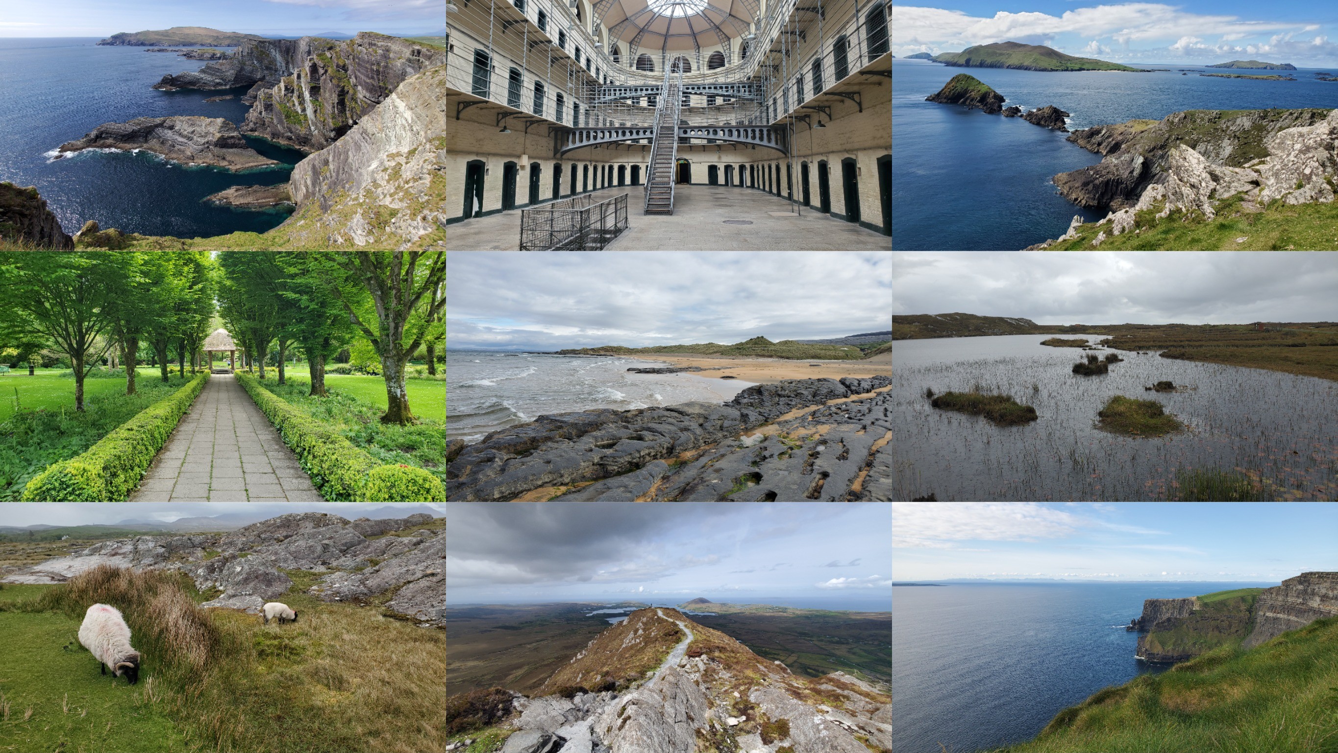
The Wild Atlantic Way
This is the rightful conclusion to an epic trilogy of mighty roadtrips, full of vast green plains and breath-taking steep seaside cliffs. We previously did Scotland's NC500, then Iceland's Ring Road. Now it's time for Ireland's Wild Atlantic Way.
Day 1: Exploring Dublin
We landed and got to Dublin on an early Saturday morning, into what initially seemed a ghost town, with the damp streets empty and quiet. The hotel neighborhood was central, yet a bit dodgy. Nonetheless, we got to exploring, as we always do.
The first stop was Trinity College Dublin, which offered a joyful walk through the grounds, with not a few similarities to Cambridge. You can really feel the weight of the place, especially in regards to its literary exports, famous worldwide. Very close to Trinity are the National Gallery and the National Museum of Ireland (Kildare Str). In the latter one can see various archeological artifacts with Celtic motifs, as well as gruesome human remains preserved in the Iron Age boggy terrain.
St. Stephen's Green was a nice little park close by, while Grafton Street is where it starts to get quite busy in terms of pedestrian traffic. Street musicians, singers, and traditional Irish dancers make it a lively place, bustling with activity. All in all, the initial feeling of an empty Dublin was radically transformed into a permanent feeling of a packed Dublin. Turning west one can find things like the Molly Malone statue and the Dublin castle, which houses numerous treasures.
Further west, passing some massive stoney cathedrals, like St Patrick's, one reaches Kilmainham Gaol, a former prison. Its significance is as follows: from 1801 Ireland was formally part of the United Kingdom of Great Britain and Ireland. Its Irish Parliament was abolished. And it was Westminster that made the legislative decisions. This created a lot of conflicts between Irish nationalists (Ireland should govern itself), Irish republicans (Home Rule is not enough; Ireland should be fully independent), Irish unionists/loyalists (Ireland should remain in the UK), and the British state itself. Kilmainham held many figures connected with Irish nationalism and rebellion and some executions have taken place there.
Overall, a great first day. For dinner we went to the Brazen Head (apparently established all the way back in 1198). The name comes from a belief in a mythical automaton. Pub culture is pretty fun in Ireland. It's nice to have some food and drink in a cozy lively environment.
Day 2: The Road to Killarney
Day 2 was a cross-country driving day, from Dublin all the way to Killarney (church of sloes). Depending on the road selected, one can pass through the scenic towns such as Limerick and Adare. We had a pleasant drive, despite the on-and-off rain, and listened to Lord of the Dance for extra thematic background. In fact, the songs had a profound effect and lived rent-free in our heads for the rest of the trip. In terms of scenery, the countryside is, naturally, green and picturesque with occasional sheep and cows dotting the pastures. Farmlands are often enclosed with short stone walls made of simple stacked rocks. One's gazing eyes find everywhere green whimsical hills and forests, with plenty of dark grey churches and castle ruins.
The little town of Adare was quaint and lovely. I particularly enjoyed the shady greenness of the town park and the Holy Trinity Abbey Church. The latter was used by a Trinitarian order with the goal of rescuing, by ransom, Christian hostages taken during the Crusades in the east. The monks that lived here ate pigeons and wore white robes with a traditional cross in the foreground.
Killarney was also a very fun, colorful, and lively town. It was cold and raining but the people were out, enjoying themselves as if 'twas nothing, with locals and foreigners, toffs and plebs, all gathered for a motor rally, coincidentally on the same day as when we were there, and about which we had zero prior knowledge. Imagine one pub blasting modern music while just around the corner people are dancing to the upbeat tunes of traditional Irish fiddle - a fun, musical setting.
Day 3: The Ring of Kerry
From day 3 onwards we were on the rugged fjords extending into the Atlantic ocean. Now we're talking. The day started with two short early morning walks in the green damp grounds of Ross Castle and Muckross Abbey. The latter was especially cool and meditative. Following that, we went on a very strenuous tiring loopy two-hour hike from Torc waterfall, with a challenging hillclimb in the middle. The best hike in the region is allegedly Carrauntoohil which I so wish I had the time to climb. Alas, it remains for our next visit.
What followed was a long scenic drive along coastal roads and villages, with fantastic views and nerve-racking bends. I particularly enjoyed Derrynane beach - a big fjordy, rugged pristine white sand beach with clear blue water and grasslands close to the shore. We found an unfortunate masked crab on the sand, that had met its maker not long before we set foot on that beach.

Тhere are too many scattered vistas and attractions to list further west. So I'll recount only the spectacular Kerry cliffs, towering at up to 300m above sea level, and the Rossbeigh beach, an elongated piece of land with beaches on both sides and grassy dunes in the middle. The Kerry cliffs were pretty entertaining, with sharp vertical ledges and dark blue shimmering foamy Atlantic water beneath them. A pair of binoculars is recommended at such places, so one can inspect the details and textures which they'd otherwise miss. Also useful for seeing the sharp contours of the Skellig islands.
The final destination for the day was nothing short of iconic, the Ballyseede Castle Hotel. I've never thought I would sleep in a castle, but it was crazy affordable and I had to go for it. Altogether it was a posh, fun thing to do. The castle itself is pretty atmospheric - stone rooftop, enclosed gardens with a foresty biome, vines going up the facade, horses and donkeys roaming nearby. The interior was luxurious and royal in style. Breakfast was traditional: full Irish + tea.
Day 4: Dingle Peninsula
For day 4 we had set to cover the Dingle peninsula. After leaving the castlegrounds, the first destination was Inch beach, a stunning stretch of sand and dunes. It's huge, spanning the entire horizon of your eyes. With a low tide it feels like you're walking in a desert where it had just rained and the remaining puddles of water are quickly seeping into the sand. Too bad the weather was pretty hostile - cold and windy.
Close by are the ruins of Minard castle and the Conor pass, a very nasty mountain road winding left, right, up and down. We had done Bealach na Bà in Scotland, but chickened out of this one and couldn't be bothered. The next stop was Ventry beach, another long and wide good-looking beach. From there begins a very panoramic stretch of road called Slea Head Drive, that follows the westernmost tip of the peninsula. It's very much worth parking and going to Dunmore Head to see the epic sharp cliffs shredding through the blue water. Further down the road one arrives at the Cé Dhún Chaoin pier, a steep dramatic pier where fewer people and more sheep were being transported from the nearby Great Blasket Island. The island’s eventual abandonment in 1953 is a fascinating case study in demographic collapse. As the modern world industrialized and youth emigrated, the aging population simply lost the physical manpower required to row their traditional canvas boats or harvest turf, forcing the collapse of their subsistence economy and a state-led evacuation.
Further north there are more beaches, harbours and rugged coasts. Yet, around 6pm, if not later, we started a little (not really) hike toward Mount Brandon. It was a very pleasant climb up the mossy foggy mountain, though regrettably we had simply run out of time. Nonetheless, we almost climbed it and the views from above were spectacular. Our hotel in Dingle was cozy and central. Dinner was naturally in a well-chosen gastropub. It was also nice to walk through the town's harbour, which featured various inshore potters / creel boats, netters, and trawlers.
Day 5: The Drive to Doolin
The next day we travelled further north to county Clare, along the rugged Atlantic coast. The attractions were fewer but compensated in terms of quality. We passed through the Adare village, mentioned above, and then saw Bunratty castle, a lovely 15th century castle. It's actually a tower house and it's interesting to imagine how people used to live there and how each interior floor was organized. I'll remember Bunratty also because of a massive colony of crows and ravens in the trees outside, loudly and remorselessly cawing non-stop.
The next attraction was the lovely town Lahinch, along with its beautiful sandy beach. The water was surprisingly warm and I had an outstanding walk there, one of the best throughout the entire trip. Something about the crystal water and the extremely wide swash zone just fell right. The main attraction for the day were the Cliffs of Moher - an epic range of vertical cliffs extending into the ocean, that has long since become a staple of Irish tourism. It was nice also to learn about the region: wildlife (birds, puffins, crustaceans), kelp forests underneath the water surface, cave systems, including underwater, fishing equipment such as crabpots, and so on. Interesting if you've played the game Dredge.
Just a bit north we saw the picturesque Doonagore castle sticking out of the green landscape. The Aran islands should also be visible from somewhere around here. The resting place for the day was Doolin, a small whimsical, sparsely-inhabited village that looks like it belongs to the Shire. The village was picturesque, with cows, donkeys, horses roaming about, and a small river and bridge in between all this. For dinner, we went to a musical pub where we listened to traditional Irish music while drinking beer and eating Irish stew.
Day 6: Into the Marshlands
Leaving the beautiful Doolin, the landscape changes rapidly further north. One enters The Burren, a vast area of karst/glaciokarst rocks. Suddenly, green turns to gray. This exposed limestone landscape acts as a massive thermal sink, absorbing solar radiation in the summer and slowly releasing it through the winter. This geological anomaly breaks standard biome distribution rules, creating a bizarre environment where Arctic-alpine plants grow side-by-side with Mediterranean flora. The Fanore beach was our first stop where we enjoyed the clear water and sandy dunes. There's also an intimidating sign to avoid potentially deadly rip currents. The second stop was Dunguaire Castle, a nice little scenic castle.
Further north, beyond Galway, we enter county Connemara, one of the most traditional, Irish regions in the country. The biome here very much resembles that of Scotland - brown shrublands, dark lakes, peaty fields. At one point there was a small lake with an even smaller island in it. You can park, walk over to the island (there's a rocky pathway over the lake) and explore it. It takes something like 3 minutes to reach the top. It's a short fun activity.
Instead of sticking to the main road, we decided to take an adventurous detour in the Roundstone bog. This is a very remote, boggy, marshy region with tens of scattered rugged lakes. The biome itself is amazing. And the setting made it all the more memorable: thick gray clouds, unsparing rain, and no other humans in a wide radius.
Eventually we reached Derrigimlagh which is a place with historical significance. This remote stranded bog was the place where Guglielmo Marconi established a groundbreaking transatlantic wireless telegraphy station. It is where the first regular wireless messages across the Atlantic were sent from. Additionally, the site is also the endpoint for the first non-stop transatlantic flight in history. We did a very nice long walk in the bog, where you can see the remains of the these events: condenser house, generators, power station. There is a brilliant technological paradox here: to generate the immense voltages required to blast the first wireless signals across the Atlantic, Marconi’s engineers built a local power station fueled entirely by the surrounding peat. They powered the world's most cutting-edge communications network using hand-harvested, decayed plant matter. After Derrigimlagh we went to the nearby seal observatory where we got to see a seal! Dinner was in Clifden.
Day 7: Connemara
Day 7 was pretty nice and had us traveling in 3 counties: Connemara, Mayo, and Galway. The first attraction for the day was Sky Road, near Clifden. It's a beautiful 16km loop that climbs a hill and allows you to see Connemara from above, spotting towns, harbours, meadows, and rivers. Our next destination was the famous Diamond Hill hike, in the Connemara national park. This was a great experience, tiring but rewarding. You walk deep within the Connemaran shrublands, covered in peat and brown moss. The climb to the top of the hill is arduous but very much worth it. The views are amazing. We also saw a very nasty hairy Oak eggar caterpillar.
Close to Diamond Hill is Kylemore Abbey, a monastic complex that is so picturesque that you wish to take a photo, print it, cut it into puzzle pieces, and assemble them again. Further north is the Aasleagh Falls, a pretty little waterfall, where on a good day you can see salmon swimming and jumping up the stream. We also spent some time in the small village Cong. This was a particularly pleasant and peaceful visit, perhaps because it was an optional destination for us and it was unclear whether we should go there at all. Cong is pretty interesting in a contemplative/somber kind of way. There's an old Celtic monastery, the Cong Abbey. A lake and a marshy river connect to it. There's a stony hut in the middle of the river, with a hole in the floor so the monks could stay inside while fishing in the winter. Crossing the river is a bridge. A stony gate with an engraving of a gnarly royal face on top guards the nearby Cong woods. We stayed in Galway for the night.
Day 8: Return to Dublin
Galway had quite the atmosphere for a city with just 85K people. My first impression was how uniformly gray and black most things were. This includes the Cathedral, the nearby bridge, and the river (at least during the prior evening, because of clouds). But I soon came to appreciate this and started viewing it as something unique. In the morning the city was lively and bustling with life.
The Galway city museum was interesting. It covered the development of the city from a small walled naval base to a major trading port; its governance by a merchant oligarchy, subsequently the English crown; the hardships of the Great Famine; the Claddagh fishing village and ring. The Claddagh wasn't just a neighborhood; it operated as a fiercely independent maritime syndicate right outside Galway's walls. They ignored English law, elected their own "King" to settle disputes, and maintained a total local monopoly on fish using their specialized fleet of Galway Hookers. We also visited the university's grounds, which were nice, but obviously can't hold a candle to those of Dublin.
A note on the Great Famine. A common interpretation blames laissez-faire capitalism, arguing an unregulated market simply exported food to the biggest market. But why was there no local Irish market? Centuries of British legislation, specifically property bans and forced land subdivision, had systematically stripped the peasantry of the ability to participate in capital accumulation. Consequently, when the blight hit, the market allocated Ireland's unaffected cash crops (grain, meat, dairy) to English buyers who could actually pay. The local population starved because earlier state interventions had systematically ground down their purchasing power. Is this not the ultimate macroeconomic factor contributing to the tragedy?
In the evening we went back to Dublin for a final pub dinner and a stroll in the city. The ambience of this place on a Saturday night is really something... Packed with people, music, a festive vibe all around. I'd say the pub culture was a very important, even fundamental ingredient of this roadtrip. It's just not the right way to spend your time in Ireland if you don't go to a musical pub, eat fish & chips, irish stew, etc. The place we went to was really all you can hope for in this regard: the Hairy Lemon. Here's the explanation: "Hairy Lemon was one of the most famous of all Dublin characters and more than likely got his name from his odd appearance. His face was lemon shaped with the complexion of his skin akin to that particular fruit and stubble of hair resembling that which grows on a gooseberry. Hairy was to be seen roaming the streets catching stray dogs for the police during the nineteen forties. He died in the fifties."