Episodes From The Land of Ice and Fire
We've always wanted to do a trip in Iceland. We've talked about it for at least 5 years now. Plans got serious last year, but we didn't manage to get organized in time. This year it finally happened, and it was spectacular. Definitely a lifetime achievement to remember. How can this little island in the middle of the ocean pack so much scenery, biodiversity, and grandeur into it?
Day 1 - The Golden Circle
What a crazy day. Our plane landed in Keflavík around 00:10am, in the night. We picked up the rental car at 00:30 am. From there we went to a nearby guesthouse to get at least a few hours of sleep. Around 8am we were already in the car travelling towards Reykjavik and beyond.
The first stop was at the Þingvellir National Park, where some mandatory attractions stand. The Almannagjá Gorge is basically a huge fault, or a rift, that marks the Mid-Atlantic Ridge - a tectonic plate boundary that separates the North American and Eurasian plates. A short walk away is Öxarárfoss, a beautiful picturesque waterfall. I liked that it was relatively hidden by the surrounding rocks and you have to walk a path between them to see it, so there's something like a build up to its sighting. After we hiked around, we got to see also Silfra, where scuba divers can swim in crystal clear water between the tectonic plates. There were lots of eager novice divers there, and an instructor, like John the Boptist (shoebody-bop-do-do-do-dooo...), was setting them off on their ~250-300 meter swimming path.
After Þingvellir, we visited another waterfall called Brúarfoss, again very picturesque, but this time with distinctly blue water. Its color comes from glacial meltwater and the way light interacts with fine sediments in it. The next stop was the Geysir geothermal park, which provided an abrupt change in scenery, where the green shrubbery suddenly changed to ochre soils and green-yellowish sulfuric deposits. The main geyser here is dormant and last erupted in 2016. A nearby smaller one erupts once every 6-10 minutes and is much more tourist-friendly. You can actually stand nearby and get covered by the silica-rich, slightly alkaline water erupted, like I did. The entire area is very interesting, with small sulfur fumaroles, vivid colors, and multiple hot springs.
The last of the mandatory tourist destinations was Gullfoss, one of the biggest waterfalls in Iceland. You can view it from afar or up close. The latter requires that you traverse a short path covered by the waterfall's mist and vapour, so bringing waterproof clothes was useful. Wherever the mist reaches, moss sprouts. Gullfoss itself was mesmerizing, thunderous and epic. And the water is clear, compared to other waterfalls we'd encounter later on.
After the waterfall, it was getting late and we had to drive to our destination for the day, the town Hella. We stopped by the Kerið crater, and we hiked around it. You can go down in the crater where there's a lake, you can see and smell interesting mosses, or simply enjoy the feeling of hiking inside the remnant crater of an ancient volcanic vent. Honestly, it's less impressive than it sounds. The real active volcanoes are Hekla and Katla.
We reached Hella late, had traditional Icelandic lamb soup in a nearby restaurant and slept in an igloo, made of glass and tiled into hexagons. Sunset was around 11:30pm and sunrise around 3am. There were lots of birds around us, making unfamiliar noises - one would squeak like a plush toy, another would drone, while yet another would wail. ChatGPT can list some typical birds and you can listen to their calls. The bizarreness of some of them can make you laugh (e.g. Eider duck).
Day 2 - The South Coast
What a day... We left the igloo at Hella and headed to the first attraction along our route to Vík - Seljalandsfoss, a big, powerful waterfall. With it commences a long stretch of road, offering incredibly scenic and dramatic views of many waterfalls and highlands. Why? Well, during the last Ice Age the coastline of the island was closer to the highland. Over time the coast moved outward while the old sea/cliff line stayed where it was. Every little stream coming off that higher land suddenly reaches the “step” and has to drop down, creating a waterfall. Many people say this is the best region in Iceland.
At Seljalandsfoss you can see the waterfall from all yaw directions by carefully following the mossy wet basalt ledge around it. The water pools into a small pond. However, while behind the waterfall, there's a small rocky region where a part of the water sometimes falls (mostly when its windy). Wearing a waterproof top, I proudly took this opportunity and stepped there. Now I know what standing under a waterfall feels like. Further down, there's another waterfall called Gljúfrabúi, which is also a highlight. It's rather tucked into a tight canyon and you have to cross a shallow glacial river to see it from close. It's like you're in Skyrim or something, a hidden gem.
After these waterfalls we went to see an old abandoned plane wreck (the smaller one to the north, not the big one) and subsequently stopped by another waterfall, Írárfoss. This one was less touristy and we took our time. This waterfall was more dangerous than I anticipated because to get a good view of the splash area you need cross a river and the rocks sticking out are (i) jagged, (ii) slippery, (iii) few and far between. You need to have good foot-eye coordination to carefully jump over them, like a mountain goat.
Further southeast, one reaches the glorious Skógafoss, another huge waterfall like no other. Now, this area is legendary and needs some explanations. The waterfall Skógafoss serves as the end (or the start, if you're doing it in reverse) of the almighty Fimmvörðuháls mountain pass (five cairns pass). This is a very serious hike, 22 kilometers long, the weather is unpredictable and people have died here. From Skógafoss you climb up and follow the river, which goes through more than 25 highland waterfalls. Later on you leave the lush green mosses and lichen and start walking through lava fields and black gravel. You eventually pass between the Eyjafjallajökull and Mýrdalsjökull glaciers. The volcano under the ice cap of Eyjafjallajökull is the one that erupted in 2010, when European air travel was halted for six days. On the other hand, the volcano under Mýrdalsjökull is Katla, which is quite powerful. The pass ends at Thórsmörk, from which another, longer trail, called Laugavegur starts. The combination of Fimmvörðuháls and Laugavegur is one of the greatest hikes in the world. One of the best moments of this trip, for which I am very grateful, is our short hike into Fimmvörðuháls, just a few tiring hours, but forever memorable and worth it.
After the hike, driving off tired and hungry, we reached Sólheimajökull. This is the first glacier that I've stepped onto (skiing does not count). It was such an exciting, novel thing to experience. You can literally climb up on the ice, though you need to have a guide. We got as far as possible without one, before a ranger told us to turn back. But the place itself is otherworldly. The glacier surface is mostly dirty ice - a mix of old volcanic ash (tephra) and wind-blown sand/silt. It almost looks like Passchendaele - huge black hills and depressions, except here there are crevices between the ice blocks filled with pristine clear water. You can dip your whole arm up to the shoulder into glacial water. It's very interesting.
After an exhausting day of waterfalls, hikes, and glaciers we went to Vík, a peaceful town. We skipped the attractions there and went straight to the geothermal pools at the hotel.
Day 3 - Icebergs and Glaciers
Again, an epic day of hiking, wading through thick fog & rain, and racing with the clock. It was already raining in the morning and a heavy fog was settling down. I remember thinking "Hell yeah, that's what we're here for" as I was getting exciting for the adventure to come. The final destination was Höfn, a fishing town in the southeastern part of the island.
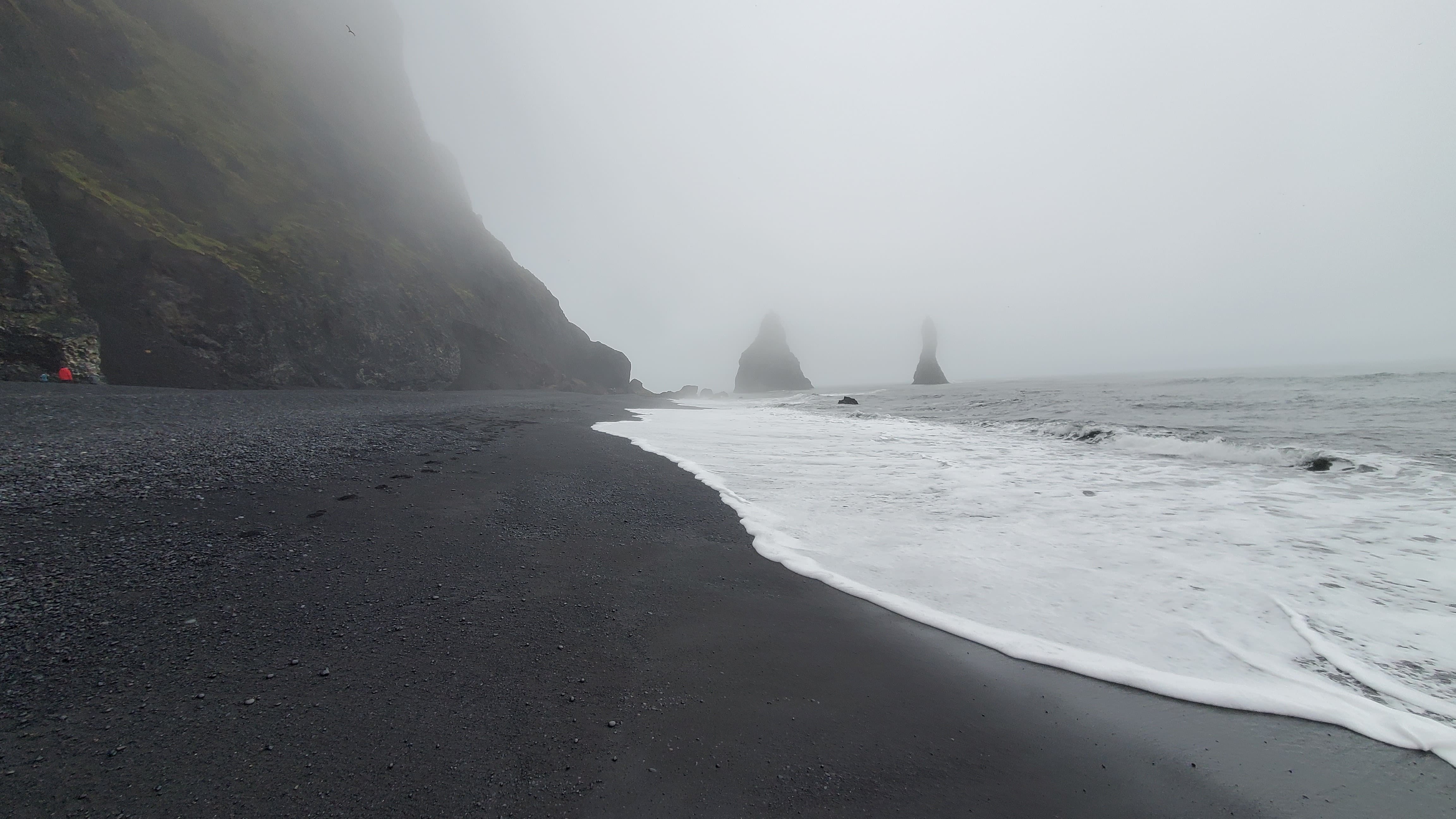
After a relaxing good night's rest and a hearty breakfast, it was time to finish what we started the previous day - the natural wonders surrounding Vík were still unexplored and this omission had to be rectified. First up was Reynisfjara beach. This beautiful beach is unique in that its sand is pristine, fine, and black. The sand further away from the main beach entry gives way to perfect round small pebbles, smoothed from all the banging, that make a loud rattling clatter as they crash against each other under the waves' force. The smell of sea and seaweed can be felt strongly when the wind is blowing toward the shore. A signpost says "Never turn your back against the sea" due to the presence of sneaker waves. Hexagonal basalt columns litter the nearby beach caves. Puffins and seagulls were nesting above them and periodically flying to the sea surface to hunt. The sky was gray with clouds and the waves were banging against the black earth relentlessly. This was a great start of the day, rich in spirit and ambience.
Subsequently, we visited Dyrhólaey, a landmass consisting of multiple cliffs and rocks, towering over the sea shore. One can explore an old lighthouse and some scenic viewing points, which were all mesmerizing. Lots of puffins nesting over these cliffs and fearlessly jumping off of them. The view from the lighthouse cliffs to the west, towards the white waves covering a huge swash zone on the black beach beneath (thematically named The Endless Black Beach on GoogleMaps), was simply epic, like something that came out of a Romantic-era painting.
Having finished with Vík, we made our way towards Höfn. The road was long and incredibly diverse. First came Laufskálavarða, a lava field where visitors have been piling up lava rocks into small pyramidal cairns, forming a whole park of these. Then came the Eldhraun lava field, created by the 1783–84 Laki eruption. This place was amazing because it's now entirely covered by moss heaths. This type of moss is very adaptive and colonizes even the most barren rocks, forming a thick soft carpet over the landscape. Further on is the stunning and photogenic Fjaðrárgljúfur canyon. It's a serpentine and green mossy structure with a river winding at its base. Pleasurable to explore.
By 6pm we had passed other dazzling biomes like grey deserts, dried up rivers, green pastures, and steppe-like fields. Around 6:20pm we reached Skaftafell, in pouring rain, and commenced our hike to Svartifoss, black waterfall, a surprisingly worthy waterfall hidden at the top of a hill. While not particularly tall by Icelandic standards, this waterfall was very pleasing due to the presence of symmetrically built-in hexagonal columns like those at the beach. By 7:40pm we were on the road again, still some 150 kilometers from Höfn.
At that time we were still quite far from any town. The roads were empty. The road was ours. Do you know how it feels to have all this landscape, all the roads and scenery only for you? It does make you enjoy yourself more and hit the gas pedal harder. Now that's a roadtrip.
Iceland is unique. Its biggest ice cap is called Vatnajökull and many glaciers and icebergs originate from it. Our path curved around its southernmost point, which allowed us to observe glaciers. Specifically, at Fjallsárlón we saw icebergs floating calmly in the sea, while an entire group of 30-35 duck-like creatures were running hurriedly, seemingly only to meet another group of ~20 other of their brethren. This spot is secluded and walking there feels like a reenactment of Roald Amundsen or any other polar explorer's expeditions. Later, at the Jökulsárlón glacial lagoon we saw additional icebergs and pieces of ice floating out to the sea. This place was amazing, picture it - 10pm, cloudy, heavy winds, chunks of ice floating out to sea, skuas and seagulls squeaking while roaming the skies looking for fish. We even saw a seal by one of the icebergs. I'm amazed at the biodiversity we observed. I guess it's useful to sometimes travel late, so you can observe different, night-time behavioral patterns, different from what you'd see otherwise. Near the sea is actually the famous Diamond Beach, where chunks of ice from the glacier wash up ashore and remain as thawing transparent diamond-like shards, contrasting the black sand beneath them. It was a great day.
Day 4 - Höfn to Egilsstaðir
On the fourth day we continued our journey to the northeast towards Egilsstaðir. The first stop was at the scenic Stokksnes peninsula. There one could see beautiful fine-grained black sand dunes, scree slopes, a lighthouse, a radar station that belongs to the Iceland Air Defense System, and a reconstruction of an old viking encampment. The last of these was just for educational purposes and was the nadir of our experience on the peninsula. Good thing that the other attractions compensated for it. It was quite windy that day, making it a bit difficult to explore thoroughly.
The drive further northeast presented delightful coastal scenery, with lighthouses, small villages, and driving in cliffy areas high above the sea. Weather-wise, we faced very strong winds, much stronger than I'd prefer. At the Hvalnes lighthouse the wind was so strong that you can almost lean against it without falling. Down the road, there were many beaches where one can take a break. A very nice black beach we went to was Fauskasandur, where a single lonesome rock stands out in the pebbly shore. There we found a perfectly preserved dead crab, intact and all, which we took with us. Its enigmatic purpose was to be revealed only later.
Further down, it is common to take a left turn from the official Ring road, to see Hengifoss, a 128 meter waterfall. Instead, we continued on the official road traveling along the east fjords, passing through various villages. The last 50 or so kilometers before Egilsstaðir were absolutely stunning - you're driving on a relatively straight road, at high speed, with beautiful green mountains to your left and right. One can observe lots of waterfalls and rivers popping in and out of view. Black and white sheep also randomly dot the landscape in the distance.
You might wonder how come all these sheep are roaming carefree all alone in the highlands. Well, during the summer they are free, grazing on fresh grass, but during the winter, they are at their corresponding farms. The réttir is the process of finding the sheep, identifying them, and bringing them back to the farm. It happens from September to mid-October. During the göngur, search parties ride horses and quad-bikes into the grazing land in search of roaming sheep. When they gather a flock, they steer it towards the valley. There, the sheep are herded into a sheep sorting pen, where farmers identify their own sheep (which are tagged) and take them back to their farms.
Day 5 - Egilsstaðir to Mývatn
The objective for today was to reach Mývatn from Egilsstaðir. There are not too many points of interest along the way, yet the ones that are, are really worth it. After leaving the city and following Route 1, the Ring road, one soon reaches Rjúkandi waterfall, the 12th tallest waterfall in Iceland and the best one for stretching your legs. Further on, one can take a detour onto a prolonged gravel road to reach Stuðlagil Canyon, which is one of my personal favourites. It's a canyon with clear blue water carving out a path between hexagonal basalt walls. This is not the first time we encounter such hexagonal basalt rocks. Here the columns are not only vertical to the riverbed, but some formations bend sideways. The water's blue color is due to the glacial silt in it.
To satisfy one's curiosity for exploring this fascinating natural location, a person like me needs to walk sufficiently close to the water and see the scene from diverse vantage points. So we dropped down to the level of the river and started walking over the rugged rocks. The colors are vivid here - saturated blue, orange, and gray for the water, ground rocks, and basalt walls. But we're not done yet, we needed to see the underwater terrain. We were carrying a selfie stick and a GoPro and naturally combined them to form an extension stick for the water-resistant camera. The videos revealed the rocky underwater landscape and the floating mosses, even though visibility was not the best. Another highlight was carefully jumping from hexagonal stone to stone while trying to not fall in the river. You see, we purposefully put ourselves in slightly dangerous memorable situations.
After Stuðlagil one reaches a new biome consisting of vast plains and hills of gray rocks and black sand. At times this barren landscape looks like a rusty post-apocalyptic wasteland and at times like the Moon surface. The main attractions here are Dettifoss, Europe's second most powerful waterfall, and Selfoss, another imposing waterfall. Dettifoss isn’t just big; it’s a powerhouse of kinetic brutality - silt-choked water detonating into a constant brown-white plume. It was a pleasure to explore the waterfall using a good set of binoculars because when you properly zoom into it you can see all the sand mixing with the water, the foamy textures, the rising mist, and the grayish rocky background. Selfoss, the other waterfall, was also quite nice, it's actually multiple smaller waterfalls falling off of a semi-circle-shaped cliff. The water then feeds into Dettifoss.
As we were approaching Mývatn, the biome rapidly changed once again. Rocky plains gave way to sandy hills. There was smoke rising in the distance. Leftfield's Song of Life was playing at that time and provided an epic musical transition to our surroundings. It was becoming clear that we're entering an active geothermal zone with volcanoes all around us.
Day 6 - The Diamond Circle
The attractions from today come from the so-called Diamond circle route. We spent a full day here, both starting and ending at Mývatn (the lake of midges - an apt name given all the black swarms of midges we had to deal with). Our first attraction was the Hverir geothermal area. It is truly distinct. It sits on the Krafla fissure of the Mid-Atlantic Ridge and features subsurface fluids with temperatures hitting more than 200°C that form smoking fumaroles, bubbling mud pots, and ochre-stained soils on the surface. The smell of sulfur is relentless. Even Nasa have trained astronauts in this moonlike landscape. If you put your hand out to one of the fumaroles it can easily burn you. And near some fumaroles, if you start jumping in place, the ground starts to vibrate and oscillate a bit, likely due to subsurface cavities or gas pockets.
Next we went to see the Krafla power station. It works similar to other thermal power plants except that the steam comes from the Earth's depths. A borehole of depth 1.5-3km is set up, which allows access to geothermal fluid (superheated water) from the Earth's crust. Specifically, heat comes from magma intrusions near the Krafla caldera. Dry steam is extracted from the geothermal fluid, and is used to push turbines connected to a generator. The steam is then condensed into water and reinjected into the Earth. It was very interesting to see the cooling tower, the drilling equipment and the individual borehole huts.
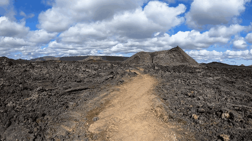
Within this Krafla region it was also enjoyable to see the Leirhnjúkur volcano, whose last eruption was in 1984. Hiking here is, again, otherworldly - black jagged rocks, winding paths uphill, and hot springs with aquamarine-colored water. You can see fumaroles and step into smaller craters. Climbing up one can very clearly see where exactly past lava has flowed. These areas are naturally black in color and form sharp boundaries between the green grass and brownish dirt.
Another geological marvel in the Mývatn area is Dimmuborgir, the dark castles. About 2300 years ago, there was a huge lava flow that started pooling over the marshy wetland of the region. When the lava ends up on top of the wet ground, it starts heating all the water in it, sometimes causing violent explosions in the process. As the water turns into steam, it rises up through the lava causing it to form lava pillars, caves, and hollow tubes. As the lava crusted over it left standing structures, reminiscent of chimneys, arches, and pillars. These are the castle-like shapes. Sometimes they've been called the gates to the infernal world.
In the afternoon, we headed to Húsavík, a very nice town on the northern coast, and very close to the Arctic Circle. There we explored the harbour, where we found a big National Geographic Expeditions ship. There is something very quaint about these kinds of small fishing northern fishing villages, and we were gonna get a lot more of it the next day. From Húsavík one can go on whale watching tours, but instead we went to soak in the nearby GeoSea baths.
Day 7 - The Arctic Coast Way
The goal for the day was to reach Akureyri from Mývatn, which only takes a bit more than an hour. There is only one big attraction along the way, Goðafoss, and therefore we decided to enrich our itinerary by doing a small part of the Arctic Coast Way, a famous route similar to the Ring Road, that follows the north Icelandic fjords and drivers along the coast.
Our first stop for the day was a viewpoint on lake Mývatn, to say bye-bye to the area and to the midges. Our second stop was Goðafoss, a splendid, horseshoe-shaped waterfall, similar to Selfoss but more "round". The water there is nice and blue, and you can go down and walk on some rocks relatively close to the waterfall.
Further on, before reaching Akureyri, we took a sharp turn north and went to Grenivík, a remote, small village on the east side of the Eyjafjörður fjord. The remote and small cannot be emphasized enough. The population there is around 350, yet it has a convenience store, a bank, and an elementary school. It felt very cozy and calm to walk along the pier in their small harbour, we even saw some locals enjoying the sunny day. From there we headed back, towards Akureyri.
We passed Akureyri and started heading north, on the west side of the fjord. The road was treacherous there, along steep mountains and going through kilometer-long tunnels (one of which was single-lane). At its top stands the mighty village Siglufjörður, a prominent location during Iceland's herring boom during roughly 1940-1960. The museum there was fascinating. We got to see a good reconstruction of the life in the docklands and the herring oil factory.
It was interesting to see the economic history of the herring boom. A new fishing technology, like the purse-seine can literally create towns, spur industries, and make people rich. It was Norwegians that first started to fish with these nets off of Iceland's coasts and to employ Icelanders there. Having to deal with increasing foreign influence in its fishing industry, Icelanders had to take matters into their own hands. The first Icelandic herring processing plant was built in Siglufjörður in 1911. Herring was either salted for human consumption or processed into herring oil (for the manufacture of soap and cosmetics) and fishmeal (used as fertilizer and livestock feed).
We saw the herring oil factory in details. Herring are first heated and turned into mash within a cooker. During this process they release oil. The fish mash then goes through a press, which squeezes out the liquids (press liquor) from the solids (press cake). The press liquor goes through a centrifuge to separate water from oil, while the solids go in a dryer where they are dried and subsequently cut into powder and packed, producing fishmeal. The factory runs on steam, generated by boilers running on coal. There are blueprints documenting everything. Neat.
After this little arctic coast adventure, we returned to Akureyri, explored the town a bit, had Thai food for dinner and called it a day.
Day 8 - The Long Drive West
This day was planned for driving west - from Akureiry all the way to Búðir in the Snæfellsnes peninsula. The main roadtrip lasted a bit more than 5 hours with a rest in Blönduós to stretch our legs and to see a church there that doesn't look like a church. Heading towards Snæfellsnes we made the bad decision to take the shorter route in miles, instead of the shorter one in hours, which led us down a long drive on very questionable gravel roads. We soon found ourselves in a very secluded region, with nobody in kilometers around us, not even sheep, and with dwindling food and water. For added effect, dark gray clouds covered the sky, it started raining, and we had to go still tens of kilometers on this gravel road. Eventually we managed to get to the main road in the south part of the peninsula. We were safe.
The highlight of the day was the Ytri Tunga beach. Which is not just any beach, it's a seal beach. It had stopped raining and some clouds were letting up. Even from the car park I saw 5 seals relaxing on some kelp-covered rocks. Since the tide was low at that time we gently walked closer to them. There, I counted 15 seals in total, all relaxing in the water on the rocks. A small crowd of other people came to us to observe. Then, out of absolute curiosity, one of the seals jumped in the water, started swimming towards us, came out on the rocks, less than 2 meters away, and laid down in front of us. It was a magical precious moment - to have a big fat round curious seal come up to you, attempting to interact. Since then, I have even more respect towards nature conservationists.
The hotel in Búðir had a fantastic location. It was far from civilization, yet close to the sea, an old solidified lava rock field, a small cove, and a black church (Búðakirkja). It was very picturesque - sea waves gently susurrating to your right, nearby sheep bleating, lava field to your left, black mountains in front. I took the time to observe the hunting habits of some birds. A gull would stand on the shore and would look for fish swimming nearby. Upon spotting one, it would jump in the water and grab it. An arctic tern however, would fly at 8-10 meters above the water and would dive sharply head-first when it sees a fish near the surface.
For dinner we went to a town called Grundarfjörður where we tried something quite nasty - kæstur hákarl or fermented shark. The dish (if it can be called so) is made of Greenland shark, one of the longest-living animals in the world, swimming in the darkness at depths up to a kilometer. Its meat is toxic to mammals and has to be fermented and dried in order to eat. The entire process takes months. It's eaten in small cube-like bites and smells of ammonia. The taste is not good.
Day 9 - Snæfellsnes
Another great day. We checked out of the hotel and headed towards the Rauðfeldsgjá Gorge. This is a small but wholesome gorge - very high rocks to your left and right, and a serpentine river at their base. It's awesome because you can walk upstream in the shady cool canyon along the river, hopping from one dry stone to another, while being surrounded by tall mossy rocks. Outside of the canyon I got stung by a bee (or some similar insect). Further along the south coast of the peninsula one reaches the Arnarstapi village, offering beautiful seaside cliffs and rocky arches (Gatklettur), but no supermarkets. Further south, one reaches the ancient village Hellnar which offers more scenic views. Here, it was packed with ducks swimming in the sea and gulls nesting on the cliffs. What a ruckus - they were squeaking like crazy. The cliffs here offer amazing opportunities to use your binoculars. You can see so many details far our into the distance - birds, waves, water ponds, sheep, people.
Continuing on, we were soon reaching the westernmost point in the peninsula. The original plan was to go to Djúpalónssandur beach, a nice black pebble beach, where one can find the remnants of an old British fishing trawler, scattered all across. We got confused with GoogleMaps and missed the turn, which turned out to be a serendipitous random event because it would lead us to something better. Snæfellsnes itself is very rich and full of attractions. There was a lot of things we could do - climb craters, or descend into lava caves. However, one only has so much time. We decided to go to a random beach called Skarðsvík near the tip of Snæfellsnes.
Skarðsvík was the real gem of the day. This beach is secluded, cozy, with a large swash zone, and has normal, golden-colored fine sand. A rocky cliff sticks out from the shore into the sea and divides the beach in half. You can go around it but you have to wade through the cold seawater, which prevents most tourists from going to that part of the beach. Yet, we are not most tourists. We made it to the other side and had that part all to ourselves. That side was splendid - clear water, small waves, interesting bulbous rocks covered in seaweed, and black rocks on the back of the beach. I entered the cold Atlantic water up to my knees and saw a flat flounder/plaice-like fish. At the back of the beach we found some rocks that look like a secret door. We found no way to open it. We buried the crab from day 4 in front of these rocks and sang Amazing Grace in the poor creature's honour. Transported from one tectonic plate to another, let it now guard this secret passageway until the end of times.
Snæfellsnes was great. It had a nice peaceful green-black texture all across it - green from the grasses, mosses, sedges, and black from age-old lava fields and craters. In the afternoon we headed towards Reykjavik and back into civilization. We passed through the Hvalfjörður tunnel, which is an underwater tunnel!
Day 10 - Reykjavik
Reykjavik is not the most populous city, yet feels like it, especially after doing the Ring road. It can be quite lively in the evenings, especially around the main street, where our hotel was. The first attraction we saw was the Hallgrímskirkja, a big cathedral with a creative facade, consisting of numerous columns of different heights. Apparently, the inspiration comes from the hexagonal basalt columns throughout Iceland, but to me it looks more like a mathematical function, a wavelet if you wish. The interior is quite bare-bones. The second attraction we visited was the National Museum of Iceland, where it was interesting to read about the initial Norse settlement of the island, how Christianity was adopted later, how Norway and Denmark got more and more involved, and finally how Iceland became an autonomous country.
We spent a good chunk of time exploring the port of Reykjavik. This was tiring, yet enriching, since we got to see actual fishermen and technicians. Specifically, we saw fishermen docking, transferring containers to and from the boat with a crane, shoveling ice. We saw large ships dry-docked for repairs. We saw an American ship on a Woods Hole (Massachusetts, they have several marine science institutions there) mission to operate the OOI Irminger Sea Array. The ship was carrying a mooring, either a recovered one, or one to be deployed. These devices contain all kinds of sensors, attached to buoys. When you form a grid of them, you can collect spatio-temporal data on what changes and how rapidly. This is used to study the AMOC - the circulation pattern in the Atlantic where warm, salty upper-ocean water flows northward, releases heat to the atmosphere, cools, sometimes becomes dense enough to sink (deep water formation), and returns southward at depth. At the end of the dock there is a small green hill called Þúfa with a fish drying house and severed fish heads (looks creepy).
After the long port walk we ate fish soup and went to the airport. The sadness of the journey's end was hitting in. Yet, there was one more memorable event that can be associated, by sheer happenstance, to our little trip. Just three hours after our plane took off, Sundhnúkur erupted. A new fissure had opened up and magma was bursting out. Luckily, it's a relatively small eruption and it doesn't present any real danger. I so, so wish I had been there, to see it from up close. Could it not have erupted a day or two earlier? Anyway, we've gathered all the necessary impressions to appreciate it even more.